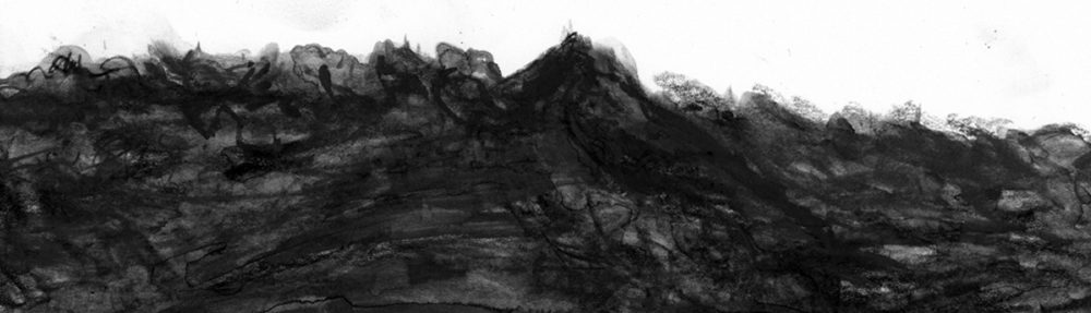
Við erum nýkomin úr aldeilis frábærri ferð með Ferðafélagi Íslands um vatnasvið Hólmsár í Vestur-Skaftafellssýslu. Gengið í fjóra daga um afar fjölbreytt svæði þar sem landmótunin er víða eins og opin bók. Þarna er Eldgjá stóri gerandinn og ógleymanlegt að standa við gjána þar sem hún klauf landið og eirði engu. Ótrúlegt að sprungan lét sig ekki einu sinni muna um að taka býsna reisulegt fjall í tvennt, ekki ósvipað og sjá má í Laka nema hvað krafturinn hefur hér verið ennú meiri svo sem glöggt má sjá þótt meira en ellefu aldir séu liðnar. Klofið fjallið ber ummerkin með sér og nafn með rentu: Svartafell.
Fyrsti náttstaðurinn í ferðinni var við Villingaskóga sem líta má á sem síðustu leifar Dynskóga á Mýrdalssandi. Frá þeim stað blasir við annað réttnefnt fjall blasir og ber í Mýrdalsjökul og Kötlugjá: Sandfell. Hafði tækifæri til þess að virða fellið fyrir mér og þá rifjaðist upp fyrir mér vangavelta frá fyrri tíð varðandi það hvernig dyngjurnar röðuðu sér upp í kringum stóru megineldstöðvarnar eftir að ísaldarjökullinn hörfaði: Ok, Skjaldbreiður, Lambahraun og fleiri umhverfis Langjökul; Trölladyngja og Kollóttadyngja stærstar út frá Bárðarbungu.
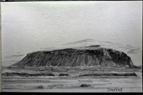
Engin eiginleg dyngja virðist hins vegar vera umhverfis Kötlu og Mýrdalsjökul og það vekur upp þá spurningu hvort öll gos utan jökuls hafi þá verið á sprungum eins og Eldgjá? Eða hvað; er kannski Sandfellið í grunninn dyngja sem hefur verið rækilega sorfin af jökulhlaupum svo sem sjá má af hlíðunum?
Þessir leikmannsþankar fóru í gegnum hugann þar sem ég sat og virti umhverfið fyrir mér. Hengdi jafnframt gulan miða á heilabúið að þýfga jarðvísindamann um þetta næst þegar slíkur yrði á vegi mínum. Ætla þá líka að spyrja viðkomandi um samspilið milli þess að allar dyngjurnar urðu til á sama tíma og jökulfarginu létti mjög snögglega í lok ísaldar. Og hver staðan er í dag. Því landmótunin heldur áfram og jöklar hopa nú sem aldrei fyrr með ört hlýnandi loftslagi.
Eins og áður hefur verið nefnt í blogginu myndi ég alveg vilja upplifa dyngjugos á minni tíð og jafnvel þótt það megi rekja til loftslagsbreytinga. Er svosem þar með ekki að gera því skóna að mannskepnan sé orðin gerandi af sama kalíber og Eldgjá. Viljinn er samt greinilega til staðar eins og stórkarlaleg áformin sýna um að sökkva Hólmsá með stíflum í ætt við Kárahnjúkavirkjun. Hefði nú talið að raskið væri orðið nógu mikið með lúpínubreiðunni austan við Atley. Mætti ég fremur biðja landa um að búa til „blátt haf“ af öðru tagi.
")
")
")
// We have just returned from a wonderful four day trek with the Iceland Touring Association. Walked some 60 km along river Hólmsá in the southern part of the country. The surroundings there are spectacular and the formation of the land can in many instances be read like an open book. Eldgjá dominates over the entire region – and truly memorable to stand on the bank of the fissure (or canyon) and take in how it divided the earth. A stately mountain even succumbed and was split in two right through, a witness to an even more dramatic event than the Skaftáreldar of 1783 (Mount Laki stood up to the fissure). From that and ample other evidence one easily senses that the events of 934 (or thereabouts) were indeed staggering in scale. Although more than 11 centuries have passed the the wound through the mountain is still scorched and devoid of vegetation, as its name implies: Svartafell (literally Black-fell).
The first night of the trip was spent by Villingaskógar, from where another aptly named mountain: Sandfell, is prominent against the backdrop of Mýrdalsjökull glacier (under which Katla lurches). Having erected the tent and finished dinner consisting of noodle-soup I had the opportunity to take a closer look at Sandfell. I recollected something I had wondered about a number of years back, that is how numerous shield eruptions occurred around the major volcanic systems in the first millennia after the ice-age glacier retreated. To take as examples: Ok, Skjaldbreiður, Lambahraun around Langjökull and Trölladyngja and Kollóttadyngja in the Bárðarbunga-system.
On the other hand you can traverse the entire Mýrdalsjökull and nowhere see the shield form. Questions arise: Have all the eruptions in the Katla-system for the past 10 thousand years been of the fissure-type? Why are there no shield volcanoes in its vicinity?
Or is Sandfell perhaps a shield volcano, since eroded by oh so many colossal jökulhlaup from the glacier, rendering the distinctive form of its slopes?
These lay-man wonderings went through my mind as I sat there watching so I made a mental note of asking a geologist about this, the next time I would encounter one of those. I’m also going to ask about the interplay between all the shield volcanoes being formed as the mass of the of glacier abruptly lessened after the end of the ice age. And how the situation is today where the glaciers retreat at an ever increasing rate. Because this restless land is likely to become even more dynamic with greater volcanic activity accompanying glacier retreat in a warming climate.
As mentioned before in the blog I would dearly like to witness a shield eruption in my time, even though it may be attributed to global warming. Am thereby not participating in the debate on causes, and whether Man is becoming an actor of the same caliber as Eldgjá. But I do take sides when the ruin of natural monuments is deliberately sought like in the gross plans to make a dam in river Hólmsá, much in the same fashion as the notorious Kárahnjúkar. I hope those plans will be thwarted.
