
It is sometimes said that the only places left to explore on this planet are to be found in the deepest abysses of the seven seas. This is probably true because remote sensing has been used to map and monitor almost every square mile of the earth’s surface above sea level. However, there are those places, where the exploration is in no way advanced or comprehensive. These places are marked on most maps with the lily-white color indicating the glaciers.
The landscape under the glaciers has been mapped and drills made to ascertain that the worlds in the ice and under it are indeed a seperate biosphere – a sui generis. Unique to these worlds are subglacial lakes uncontaminated in the sense that they may hold microbes not found elsewhere. These worlds seem to be totally void of fungi which else are found all over the planet, from the highest altitudes to the sub-seafloor.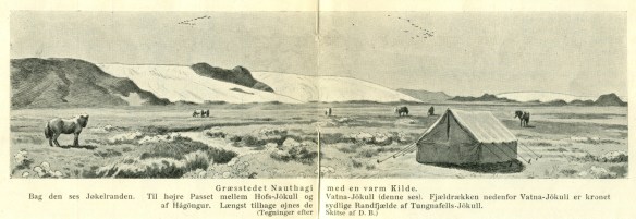
- View of Nauthagi, Þjórsárver, Central Iceland. Drawing made after a sketch by Daniel Bruun in: Routes over the Highlands, Copenhagen 1907
The retreat of glaciers reveals these worlds in a spectacular fashion. From afar the boundaries are evident in hillsides revealing the extent of the glacial surge. The grays of the freed land in contrast with the earthy browns of the hilltops exposed to the elements ever since the end of the ice age. When scaling the hillside above the boundary a whiff of fungi indicates the decay if you will and goes to show that although the glacier is in itself a very harsh force it nonetheless gives shelter to the land.
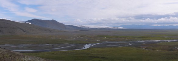
- View from Nautalda (hill above Nauthagi), Þjórsárver, Central Iceland, August 2016
The glacial processes witnessed are geologically well defined, but the perception of travelling through land released by the glacier is in many ways novel. The notion of walking where the glacier lay as recently as last year, is thought-provoking and sharpens the senses. The landscape looks and feels pristine in spite of the heavy beating delivered. Rocks and gravel issue a gun-flint smell one can easily associate with a good Riesling. Appearances close-up are those of uniformity with rolling forms where sharp edges are mostly confined to the dip-and-strike where the glacier has run over bedrock strata. The surface is mostly untouched by the freeze/thaw mechanisms so that the flow-banded rhyolite boulders, carried from the rims of the caldera deep inside the glacier, will in time be cleft into slates, occasionally imitating a loaf of bread cut into slices with a single operation.
The surface of this new-found land is intriguing in its assortment of cobbles and pebbles with an occasional boulder thrown in for good measure. One can speculate how far the vivid rhyolite has traveled while recording the contrast it renders against the abundant basaltic gray. Evident in most of the discernible shapes is the combination of sheer crushing vertical pressure along with the rolling, grinding motion of the flow direction. All this more or less embedded in a matrix of finely or not so finely ground gravel.
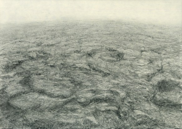
- jumble and mumble pencil drawing on paper 21×29 2018
For me the manner of depicting this relationship in a drawing takes on a semblance of the process which has rendered the motive in the first place. The grain of the intelligible set in the noise of the ground jumble. All within a frame of reference containing the points of the compass, height and depth in the landscape.
I propose to make a series of prints to capture the perception of travelling through this intriguing new-found land with its erratic grain and jumbled noise. Sketches will be transferred to an intaglio medium (solar plate or other). The plan is for this to be a series of at least 20 prints, the edition to be determined taking account of the chosen medium.


- drumlin and swirl pencil drawing on black paper + inverse rendering 21×29 2018
Tryggvi Þórhallsson, March 2018


